We had the pleasure of collaborating with Leon Spikker to develop an easy-to-use modular housing configurator for our valued Dutch client, 'In The Middle Of Our Street' BV (MOOS). The end result is a fantastic tool that we are incredibly proud of.
Feb 18, 2023
by Matas Ubarevicius
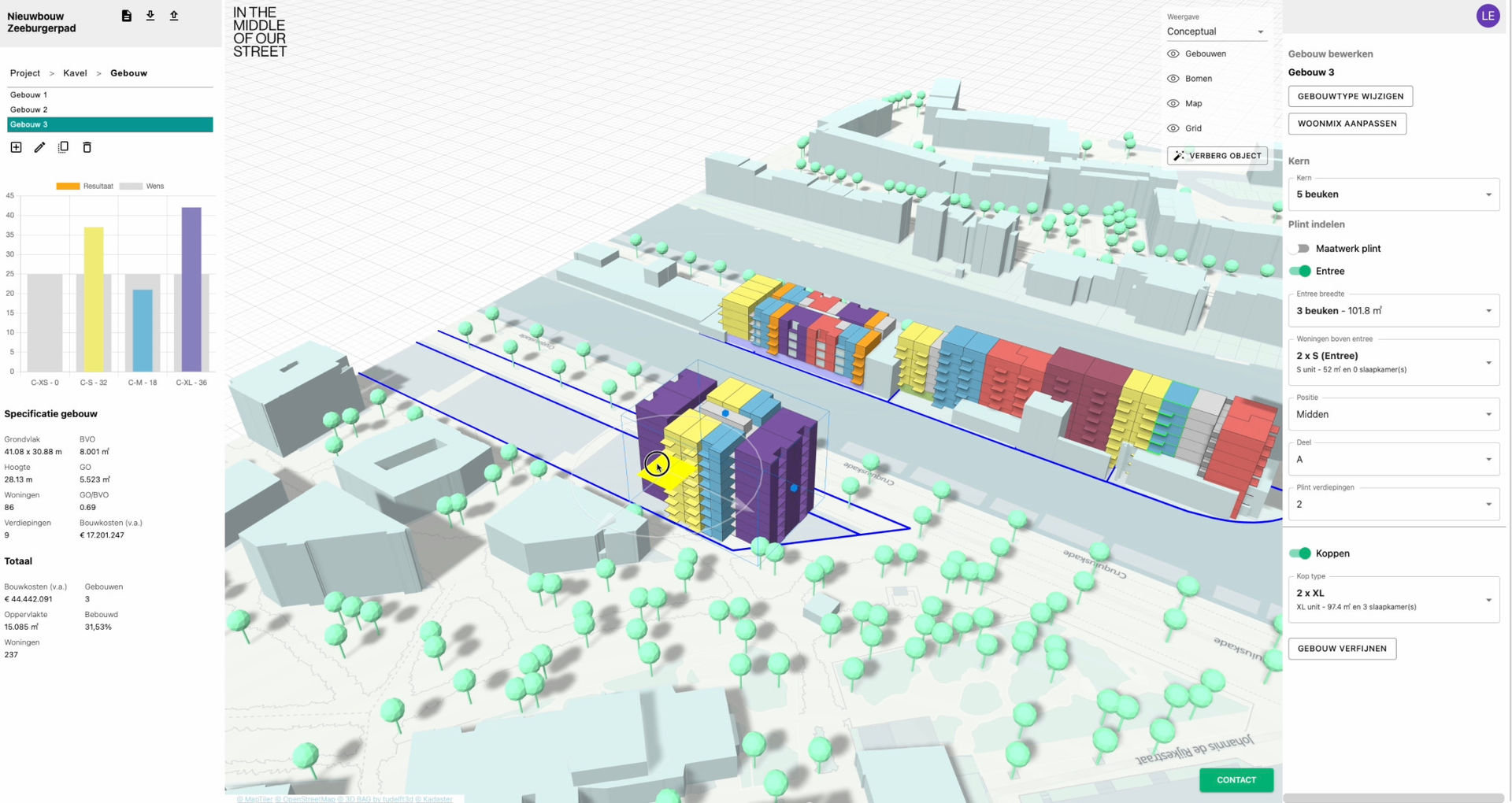
This new innovative tool simplifies the exploration of countless configuration options provided by MOOS housing modules. Our team programmed a user-friendly web application that enables users to effortlessly select different parameters and view real-time 3D model and data changes. We're thrilled to have played a part in bringing this project to life!
Housing configurator in action.
Our team's primary objective from the outset was to enable users to generate customized housing projects at any location in the Netherlands while providing access to important urban contextual information. Through our collaboration, we developed a comprehensive solution that allowed users to easily add and configure different building types to their project, with the ability to explore countless configuration possibilities with ease.
Video made by Leon Spikker demonstrates the basic capabilities of the housing configurator
While the user interface for the application may appear simple, it conceals the complexity of the sophisticated technologies that we employed to create this solution. We integrated innovative web technologies, such as 3D game engines, GIS kadaster cloud services, and other cutting-edge technologies, to develop a powerful tool that makes designing and constructing custom housing projects more efficient and straightforward.
Basic Features
The housing configurator makes it easy for users to experiment with different configuration options and visualize their impact on the environment in real-time. This feature is invaluable for exploratory purposes as it allows users to generate new ideas and concepts by visualizing their designs and information in a realistic and interactive way.
We also implemented features that enable users to create new projects and multiple sites within them, providing flexibility and control over the design process. Each site can contain one or multiple buildings, and our solution offers a range of visualization options on aggregated project, site and building levels. This approach enables users to gain deeper insights into the design and its impact on the environment, making it easier to refine and optimize parameters for maximum efficiency and effectiveness.
The configurator also offers approximate pricing information, a critical feature when it comes to designing affordable housing. This information enables users to make rough estimates of the cost of their project, allowing them to make informed decisions and adjustments to their designs based on their budget.
To make it easier for users to share their designs with stakeholders, our solution includes a PDF report feature that compiles all the information about the project, including screenshots of the site, buildings, and charts. This feature streamlines communication and decision-making and ensures that everyone involved has access to the same information, leading to a smoother and more efficient design and construction process.
Building modules can be presented in two visualisation levels: conceptual and accurate. The first level is optimized to represent XS, S, M, L, and XL modules, while the second level offers a more detailed and realistic representation of both the modules and the constructed buildings.
GIS Data Driven Design
Configurator is designed to provide users with a comprehensive and interactive view of their project's urban context. This includes the ability to view parcel zoning information, hide existing buildings, and add new ones, as well as the visualization of trees and other natural features that help users make informed decisions on where to build their structures and minimize their impact on the environment.
The housing configurator's powerful capabilities are made possible in part by the underlying Geographic Information Systems (GIS). Over the years, various organizations in The Netherlands have assembled geolocated data, which we have integrated into our application in creative and innovative ways.
This data, which is typically not available in regular CAD systems, provides valuable insights into the urban context, including zoning information, land use patterns, and natural features. By tapping into this rich source of data, we are able to offer users a more comprehensive and interactive view of their projects and enable them to make informed decisions based on a wide range of factors.
We believe that the integration of GIS data is critical to the success of any modern housing configurator, as it enables users to explore and understand the context of their projects. Our solution offers a new and innovative way to harness this valuable data and provides users with the insights they need to design and build efficient, affordable, and sustainable housing projects.
Summary
We strongly believe that developing innovative cloud-based CAD solutions powered by data is an area of immense potential. There are numerous features to be built, and countless possibilities to explore. This housing configurator is an example of how innovative thinking can help the housing industry move forward. Although there are always more features to be developed, we are proud of the success of this project and confident that it will enable MOOS to further their mission of providing affordable housing in the Netherlands.